Introduction
This document provides responses to Frequently Asked Questions (FAQs) developed by the Bird and Bat Tracking Working Group of the Regional Wildlife Science Collaborative (RWSC). These FAQs address immediate information needs raised by stakeholders seeking guidance on the design and coordination of bird and bat tracking studies related to offshore wind energy development. They are focused intentionally on high-priority topics where near-term clarity is needed; they are not intended to serve as comprehensive tracking guidance.
The information in this document reflects the collective scientific expertise of the committee and is intended for informational purposes only. Discussions of permits, regulatory frameworks, or compliance considerations are provided as general background and should not be interpreted as legal advice or as a determination of what permits or authorizations may be required for any specific activity. Permit requirements vary based on the nature of the activity, location, species involved, and other factors, and are subject to change. Readers should consult the relevant regulatory agencies and qualified legal counsel to determine the requirements applicable to their situation.
Purpose
A large number of entities are funding and implementing bird and bat tracking work aimed at better understanding offshore animal movements in the Atlantic Outer Continental Shelf. Given the number of entities involved in these efforts and the various goals of ongoing and planned tracking studies, these Frequently Asked Questions (FAQs) were developed to promote: 1) consistency in practices and implementation, and 2) the scientific utility of data collected across studies. Adoption of these best practices and recommendations will facilitate cost-effective research and ensure transparency of resulting data to answer key scientific questions.
Audience
These FAQs are primarily intended for researchers planning or conducting tracking studies, as well as agencies, funders, and developers supporting such work. Not all topics will be relevant to all users. For example, some offshore wind energy developers may have predefined focal species for tagging efforts and may not require species prioritization guidance. However, each FAQ topic has been identified by stakeholders within the RWSC Bird and Bat Subcommittee and/or the Tracking Working Group as an area where additional guidance or consolidation of existing guidance is needed, and this FAQ document represents the current collective recommendations available at this time.
Scope
The geographic scope of this guidance is the U.S. Atlantic region, with an emphasis on areas where offshore wind projects are proposed, permitted, under construction, or operational. Although tailored to this region, many of the considerations outlined here may be relevant elsewhere.
The primary methodological focus is automated telemetry via the Motus Wildlife Tracking System (“Motus”; Taylor et al. 2017), reflecting the substantial number of bird and bat tracking efforts planned for offshore wind-related studies in the near term. Some content may also apply more broadly to other tracking and biologging technologies (e.g., Argos, GPS).
Coordination & Data Management
Why Coordinate?
Why should all bird and bat tracking efforts in relation to offshore wind energy development be coordinated through the RWSC Bird and Bat Tracking Working Group?
Tracking studies are one of the few tools that can reveal offshore movements, habitat use, and individual interactions with wind energy infrastructure. They are essential to inform conservation and management and are increasingly central to regulatory decision-making for offshore wind development. Because these studies are expanding rapidly and often focus on a small set of priority species of regulatory interest, coordination is essential to ensure that tagging efforts are scientifically robust, ethically responsible, and maximally informative.
As a collaborative international system, Motus (Taylor et al., 2017) provides researchers with opportunities to contribute to a shared database and leverage infrastructure across a broad geographic range to better understand animal movements. Small tag sizes make tracking with the Motus network a particularly useful tool for studying smaller-bodied birds and bats, including many species listed under the Endangered Species Act (ESA) that are of regulatory interest in relation to offshore wind energy development in the United States. However, offshore data collection presents technological and logistical challenges, so fully utilizing these new technologies for offshore movement studies requires coordination on focal species, deployment timing and locations, and Motus station build-out to manage expectations and maximize investments in tracking effort. In addition, federal regulators have required deployment of Motus stations on offshore turbines as well as deployment of Motus tags across multiple offshore wind projects (BOEM, 2023, 2024a, 2024b, 2024c; Table 1). As a result, the volume of offshore-related tagging studies implemented or funded by developers, agencies, and researchers is increasing rapidly, creating a clear need for region-wide planning. The RWSC serves as a coordination hub for offshore wind research. As a voluntary multi-sector collaborative entity, the RWSC supports collaboration and coordination on marine life and offshore wind research in U.S. Atlantic Waters. The Bird and Bat Tracking Working Group within the Bird and Bat Subcommittee was established to address this need and to bring together focused expertise on bird and bat tagging to support coordination efforts. For all bird and bat tagging studies with interest in offshore movement in the U.S. Atlantic, it is recommended that funders and researchers coordinate with the RWSC Bird and Bat Tracking Working Group. The process for coordination is detailed in the section RWSC Coordination Process.
Coordinating tracking studies through the RWSC Bird and Bat Tracking Working Group provides the following benefits:
- Efficient use of tags, infrastructure, and limited permits: Many focal species have strict permit requirements for handling, especially ESA-listed birds and bats with small populations. Coordinated planning avoids unnecessary duplication of efforts, reducing stress on animals and risk.
- Leverage existing resources and identify funding opportunities: Collaboration across field efforts can maximize resources and leverage individual expertise with a species or technology. Collaboration may also lead to identification of additional funding to support new or ongoing project efforts.
- Consistency in methods and data standards: Early alignment on tag frequencies, burst intervals, attachment methods, and data/metadata standards improves data comparability, reduces preventable data loss, and facilitates regional-scale analyses.
- Strategic offshore Motus infrastructure: Coordinated installation, calibration, and maintenance of coastal and offshore receivers improve detectability of tagged animals, fill network gaps, and increase the value of every deployed tag. Shared logistics and troubleshooting can also reduce project costs and downtime.
- Integration across the growing number of offshore wind-related tagging efforts: Multiple developers, agencies, NGOs, and academic groups are planning deployments. RWSC coordination ensures these efforts complement rather than duplicate one another, and that results contribute to a regional understanding of offshore movements.
- Leverage subject matter expertise: The Working Group convenes species and technology experts who can provide insight on study design, methodological decisions, regulatory considerations, and practical challenges unique to offshore environments through regular RWSC Working Group meetings, and provides a network of potential project partners with relevant expertise.
- Alignment with the RWSC Science Plan: The RWSC Science Plan (2024) identifies coordinated bird and bat tracking as a regional priority for offshore wind research. The Bird and Bat Tracking Working Group was established specifically to operationalize this priority and provide the structure needed for effective coordination.
Bird and Bat Tracking Working Group Objectives
- Convene subject matter experts to coordinate bird and bat tracking projects in the U.S. Atlantic
- Prioritize tag deployment for bird and bat species offshore
- Identify research and data gaps
- Support study design, protocols, and planning
- Facilitate partnerships and logistical coordination
- Promote data sharing, metadata standards, and access
- Support collaborative regional analyses
- Communicate and disseminate results
Proposed Motus tagging efforts by active offshore wind energy projects in documents made public by BOEM
| Project ID | Bird tags (per year) |
Bat tags (per year) |
Species | Years | Total tagged individuals |
|---|---|---|---|---|---|
| Empire Wind1,2 | 130-300 | 0* | Piping Plovers, Red Knots, Roseate Terns | 3 | 390 |
| Sunrise Wind3,4 | 150 | 0 | Piping Plovers, Red Knots, Roseate Terns* | 3 | 450 |
| Revolution Wind5 | 150 | 0 | Piping Plovers, Red Knots, Roseate Terns* | 3 | 450 |
| Vineyard Wind 16 | 150 | 0 | Roseate Terns, Common Terns, nocturnal passerine migrants | 3 | 450 |
| South Coast Wind7,8 | 130-300 | 0 | Piping Plovers, Red Knots, Roseate Terns* | 3 | 390-900 |
| South Fork Wind9,10 | 50 | 0 | Roseate Terns | 3 | 150 |
| TOTAL | ~2,280-2,790 |
RWSC Coordination Process
What is the process for coordinating bird and bat tracking efforts through the RWSC Bird and Bat Tracking Working Group?
Bird and bat tagging studies that provide information about offshore movements and interactions with offshore wind development in the U.S. Atlantic are being funded and carried out by state, federal, industry, non-profit, and academic partners. Because many of these efforts focus on overlapping species, regions, and study questions, early and ongoing coordination with the RWSC Bird and Bat Tracking Working Group is strongly recommended (see Why Coordinate?).
Research funders
Funders developing RFPs for bird and bat offshore tracking studies should reach out directly to the RWSC Research Director, Julia Dombroski (julia@rwsc.org). RWSC facilitates research funding coordination through a dedicated forum that is separate and independent from RWSC subcommittees and working groups to prevent potential conflicts of interest. This forum facilitates research coordination by promoting discussions among funders and providing guidance and examples for all stages of the RFP and procurement process, including how to incorporate coordination expectations, data governance and sharing requirements, and budget allocations to cover these activities.
Researchers
Researchers developing study proposals or plans for offshore bird and bat tracking should initiate the coordination process by contacting RWSC Bird and Bat Subcommittee coordinator Zara Dowling (zdowling@umass.edu). Zara can identify relevant topics from past or upcoming RWSC Bird & Bat Subcommittee meetings and assist with the recommended coordination activities outlined below.
Planning of Research Projects
During the project planning stage, the researcher or principal investigator develops the study plan, including scope, personnel roles, and timelines. Often this work is conducted as part of drafting a proposal, or as part of defining a specific scope of work between proposal acceptance and the finalization of a grant award or contract.
In the project planning stage, researchers are strongly encouraged to take the following actions:
Attend RWSC Bird and Bat Subcommittee meetings – Subcommittee meetings are public forums that enable participants to stay up to date on offshore wildlife research being conducted by members of the RWSC community (Meeting links and agenda).
Reference available databases and planning tools – Researchers should review the RWSC Research Planning Map, the RWSC Research Database, the RWSC Bird and Bat Tracking Working Group Project Database, the Motus Data Explorer, and Movebank to assess current tracking work being done in a particular region or with specific species of interest. The RWSC Bird and Bat Tracking Working Group Project Database is a centralized location for information on tracking studies focused on offshore movement data. The database is managed by the Working Group and is used to update other RWSC resources (i.e. the Research Database and Research Planning Map) regarding studies specific to tracking birds and bats.
Incorporate coordination activities into project proposals, study plans, and budgets – Researchers should incorporate specific coordination actions into proposals or study plans. For example, prior to project kick-off, researchers should plan to engage with the RWSC Bird and Bat Subcommittee and/or Bird and Bat Tracking Working Group to inform selection of focal species, tag types, deployment locations, and/or other planning logistics. Researchers should also plan to provide research updates at regular intervals to the Subcommittee and/or Working Group. Recognizing that coordination requires time and effort, we recommend allocating staff time to carry out these coordination activities into project budgets.
Incorporate data management and sharing into project proposals, study plans, and budgets – Researchers should develop plans for making data publicly accessible (as appropriate) in databases recommended by RWSC. Data Management and Sharing Plans (DMSPs) should be used to detail plans for data management in a clear and consistent manner. Staff time should be allocated in project budgets to allow for QA/QC of collected data, appropriate formatting for identified databases, database fees (if any), and other planned aspects of data management and sharing.
Implementation of Research Projects
The Working Group recommends that all bird and bat tracking projects that have secured funding complete the following steps to coordinate with RWSC:
Schedule a time to present at an upcoming RWSC meeting – Reach out to the RWSC Bird and Bat Subcommittee coordinator, Zara Dowling (zdowling@umass.edu), to schedule a time to present to the RWSC Bird and Bat Tracking Working Group and/or the Bird and Bat Subcommittee on the planned project and receive feedback on the proposed study plan. Topics of discussion may include focal species, study locations, methods, study design, data management and sharing, and other relevant topics. Researchers may also request detailed feedback on study plans in written format.
Submit project to the RWSC Bird and Bat Tracking Working Group Tracking Database – The project should be submitted to the tracking database via the online submission form. Basic project information is required, including study objectives, focal species groups, tagging locations, and basic methods. The Bird and Bat Tracking Working Group will directly reach out to project Principal Investigators (PIs) to request regular project updates, including changes in project status (proposed, active, or completed) or updated project details to be submitted via the project update form. Project submission and update forms are available on the RWSC Bird and Bat Tracking Working Group Webpage for PIs to access as needed to submit new or update existing projects. The project submission will be used to update the RWSC Research Database to minimize the information researchers are asked to submit.
Submit study location information to the RWSC Research Planning Map – Study locations, once known, should be added to the RWSC research planning map via the online submission template.
Provide regular updates at RWSC meetings – It is recommended that researchers regularly attend Working Group and/or subcommittee meetings to share occasional (formal or informal) project updates and identify further coordination opportunities with new projects.
The Bird and Bat Tracking Working Group will be developing a more structured coordination framework in 2026–27.
Data Management
How should Motus data and metadata be managed for offshore bird and bat tracking studies?
As a collaborative network for automated radio telemetry, Motus leverages coordination of infrastructure and data sharing across a network of researchers through an open data framework. The model framework relies on FAIR principles facilitating data sharing and ensuring proper permissions and acknowledgments to collaborators. The Motus model framework is similar to eBird or bird banding programs, where all data is submitted and stored in a central repository (Motus) and in turn, the data is shared among users. As such, individual researchers have access to both (1) detections of their tags across all stations and (2) detections of all tags detected on their stations.
The success of Motus depends on researcher participation in the shared database through proper registration and diligent management of Motus tag and station metadata. Minimum metadata standards specific to offshore Motus stations were developed as part of a larger package of guidance documents for deployment and use of Motus at offshore wind energy facilities. See The Atlantic Offshore Wind Collaborative Research Group page on Motus to access the suite of guidance. More information on data sharing and metadata standards can be found at (https://docs.motus.org/en). The Motus Collaboration Policy provides comprehensive information on data management, access, and agreements for Motus data and metadata (Birds Canada, 2023c). Motus detection data can fit into two general categories:
Summary Data
Basic project information includes station and tag metadata and daily summaries for tag detections and tracks. This data is publicly accessible for viewing and download on the Motus website. It’s important to note that summary data provides an overview of detections but does not provide detailed information necessary to identify false positives and perform many analyses, which is only possible with Complete Data access.
Complete Data
Complete data provides additional information beyond summary data, including signal strength and direction, precise time stamps, and additional metadata fields that are needed for thorough data cleaning and analysis. By default, access is restricted to registered Motus collaborators and is available for download through the Motus R package (Birds Canada, 2026).
Data Accessibility
Data access (detections and metadata) is crucial for to support ecologically meaningful research and analysis. As such, we recommend that all Motus station data, tag data, and metadata be provided as non-proprietary information that is accessible to all registered Motus users in line with the default data access setting, ‘Open Detailed Data’ for Motus projects (Loring, Carlson, Gobeille, Makenzie, et al., 2023). It is also recommended that projects be designated within Motus as part of the Atlantic Offshore Wind Group. Designating a project as part of the Atlantic Offshore Wind Group does not change the way data and metadata are managed, but it allows for summary-level data across Group projects to be viewed at the regional scale (Loring et al., 2023).
PIs have the option to restrict access to Complete Data to project collaborators for 5 years, after which Complete Data will become open. While this is an option, the Working Group strongly recommends that data remain open, consistent with best practices for open data access. Prior to using data (summary or complete), researchers should correspond with Motus project PIs/data owners and properly acknowledge and cite the Motus project and project collaborators (Birds Canada, 2023c). A log of Complete Data downloads through the Motus R Package is available to PIs, who are responsible for monitoring data access and responding to collaboration requests.
Project Information and Coordination
The RWSC Bird and Bat Tracking Working Group is serving as the coordination hub for tracking research aimed at understanding offshore movements of birds and bats in the U.S. Atlantic, including Motus-related projects. This Working Group contributes to the RWSC’s core purpose of ensuring appropriate data and standards are in place to support scientific priorities (Regional Wildlife Science Collaborative, 2024). To that end, the Working Group manages and regularly updates the Tracking Database, which compiles information on ongoing, future, and completed tracking efforts for birds and bats in the U.S. Atlantic. This database is primarily used to aid in coordination, such as informing the design of new projects (e.g., to avoid duplication of effort) and connecting researchers with potential funders looking to support research efforts. Organizations that are planning to deploy tags (or are actively deploying tags) should submit a brief summary of project activities to the Tracking Research Database using the new project submission form (see RWSC Coordination Process).
Species Selection
Bird Species Prioritization
How should we approach species prioritization for tracking birds in relation to offshore wind energy development?
Several existing guidance documents and frameworks have identified criteria that can be used to prioritize research and monitoring activities for birds in relation to offshore wind energy development (Avian Displacement Guidance Committee, 2024; Regional Synthesis Workgroup of the Environmental Technical Working Group, 2023; Williams et al., 2024). Additionally, existing species vulnerability indices (Kelsey, 2025; Robinson Willmott et al., 2013) and forthcoming (2026–2027) updates to the U.S. Atlantic avian vulnerability assessment can inform avian species prioritization for offshore wind-related studies. However, each research project is likely to have different considerations relating to factors such as geographic focus, funding sources, etc. (Regional Synthesis Workgroup of the Environmental Technical Working Group, 2023).
This FAQ focuses specifically on prioritizing focal species for avian movement studies in relation to offshore wind development using the Motus Wildlife Tracking System. These recommendations therefore focus primarily on small-bodied avian species (e.g., passerines, shorebirds) that are uniquely suited to the Motus system because they are either too small to carry GPS/satellite tags or have other logistical or bird safety issues that limit the use of such tags. When selecting focal species, we recommend prioritizing research on focal species hypothesized to have elevated risk levels from offshore wind development, as well as other factors such as logistical feasibility.
How to Assess Risk for Offshore Wind Energy Development
Broadly, potential risk to birds is determined by a combination of three factors: exposure, conditions and stimuli, and vulnerability (Figure 1; Crichton, 1999; Goodale & Milman, 2016; Williams et al., 2024). Exposure is the amount that an animal overlaps spatially or temporarily with the wind facility, including a species’ distribution offshore and whether flight altitudes overlap with the rotor-swept zone. Conditions and stimuli are attributes of a wind facility (e.g., lighting, distance from shore, turbine spacing) that may influence how individuals respond to the presence of offshore wind development. The final component of risk is vulnerability, which encompasses an individual bird’s sensitivity to effect (e.g., a bird’s morphology, behavior, habitat flexibility) and the population’s sensitivity to effect (e.g., related to demographics, population size, life history, and conservation status). These three factors are considered in offshore wind energy risk assessments as well as in avian vulnerability assessments (e.g., Kelsey, 2025; Robinson Willmott et al., 2013).
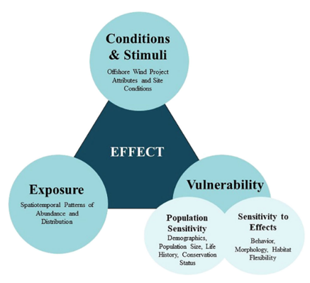
When selecting a focal taxon for avian research, the components of risk may be differently weighted depending on organizational or study goals. While researchers focused on understanding the scale of effects may choose to prioritize species with high exposure (i.e., species with a high likelihood of moving offshore and/or interacting with wind facilities), researchers considering federal regulatory perspectives often focus on species with high vulnerability (e.g., species listed under the Endangered Species Act).
Resources for identifying species with high population sensitivity include:
Species listed or identified for potential listing under the ESA (including currently listed species; species proposed for listing; and candidate species in USFWS’s five-year listing workplan)
Species listed in State Wildlife Action Plans (SWAPs), including Species of Greatest Conservation Need (SGCN)
Regional SGCN species, such as those listed for the northeast and southeast U.S. (Northeast Fish and Wildlife Diversity Technical Committee, 2024; Southeast Wildlife Diversity Committee, 2019)
Birds of Conservation Concern (U.S. Fish and Wildlife Service, 2021)
State of the Birds Report (North American Bird Conservation Initiative, 2025)
Selecting Focal Species for Motus Tracking Studies
The selection of focal species for movement studies in relation to offshore wind should take into account potential risk (discussed above in How to Assess Risk for Offshore Wind Energy Development) alongside the following recommendations and logistical considerations. Additional information on focal species for offshore Motus movement studies can be found in The Monitoring Framework for Automated Radio Telemetry at Offshore Wind Projects in the U.S. Atlantic (Loring, Carlson, Gobeille, Makenzie, et al., 2023), available at https://motus.org/resources/collaborations/atlantic-offshore-wind.
Selecting appropriate study methods
Because Motus receiving stations are still uncommon offshore, species selection should be informed by ecology and tagging locations in relation to Motus station coverage and research questions (see Where and when should Motus compatible tags be deployed for studying birds and bats in relation to offshore wind development?). Motus can provide presence/absence data to measure exposure at an offshore wind farm equipped with Motus receivers, and, in regions with high station coverage, can help to understand potential movement pathways. Motus is not appropriate for research questions related to studying displacement of birds from a wind farm and into areas without Motus receivers to detect them. In those cases, other tag types or methods may be more appropriate for species of interest or study objectives. Additional information can be found in Section 6.0 of the Avian Displacement Guidance (Avian Displacement Guidance Committee, 2024).
Contribute to regional knowledge base
Movement data for a selected focal species should help fill existing knowledge gaps and avoid unnecessary study duplication. This goal highlights the importance of regional coordination of tracking studies (see Why Coordinate? and RWSC Coordination Process)
Other logistical considerations
In addition to the considerations noted above, final species selection for Motus tracking studies requires explicit consideration of logistical feasibility. Identified limitations generally relate to:
Prioritizing animal safety - Limiting tag and attachment weight (relative to animal body weight) is a key factor that limits deployments of tags on specific species. Some species also suffer from reproductive or survival effects relating to handling for tag deployment, carrying tags, and/or tag attachment methods (such as harnesses), which need to be evaluated and mitigated. For additional information, see What Motus tag specifications should be used for tracking study species offshore?
Sample sizes - The ability to reliably capture and safely tag the focal species is important for achieving adequate sample sizes to answer research questions of interest.
Acquiring data at necessary spatial or temporal scales - The life history stage or location at which capture is possible may not align with the locations or life history stages of interest for understanding exposure to, or interactions with, offshore wind development. For example, capture during the breeding season, combined with tag battery life and/or attachment limitations, may make it difficult to obtain data on offshore movements during post-breeding, migration, or non-breeding periods for some species.
If an adequate sample number of movement tracks in the locations or time periods of interest cannot be safely obtained for a prospective focal species, then alternative methods and/or focal species should be considered to address the selected research questions.
Bat Species Prioritization
Which bat species should be prioritized for coastal and offshore tracking studies?
For bats, exposure to offshore wind energy facilities, risk of collision mortality, behavior around wind turbines, and population sensitivity represent important considerations (Williams et al. 2024) when identifying priorities for coastal and offshore tracking studies.
Wide-ranging migratory tree bats
Migratory tree bats (e.g., hoary bats, silver-haired bats, eastern red bats) are the species most frequently detected flying over open water off the U.S. Atlantic Coast (Solick & Newman, 2021). These species make up a large majority of the fatalities recorded at terrestrial wind energy facilities (Lloyd et al., 2023) and appear to be attracted to wind turbines (Jonasson et al., 2025). While they are not currently protected at the federal level, all three are considered Species of Greatest Conservation Need in multiple coastal Atlantic states. Modelling studies have suggested the hoary bat is at risk of severe declines due to terrestrial wind energy-associated mortality (Friedenberg & Frick, 2021), and this species was added to the USFWS listing workplan for FY 2028 (U.S. Fish and Wildlife Service, 2024). Migratory tree bats are at greatest risk of collision mortality at terrestrial wind energy facilities during the late summer to fall migration season (Lloyd et al., 2023), which corresponds to the season of highest activity offshore (Peterson et al., 2014; Solick & Newman, 2021). Given these considerations, the Working Group recommends that the highest priority for tracking projects be tagging migratory tree bats during the late summer to fall migration season. To assess fall migratory movements in relation to offshore wind, tags should be deployed in the vicinity of or north of offshore wind energy areas of interest, aiming to deploy tags in the general movement path for species moving towards warmer southern climates. To maximize value of deployment, capture and tagging of bats near the coast or on islands offshore increases likelihood for movement offshore and encountering offshore wind energy areas of interest. For more recommendations about where to deploy tags on bats, see Where and when should Motus compatible tags be deployed for studying birds and bats in relation to offshore wind development?
Migratory tree bats are at lower risk of collision at terrestrial wind facilities during spring migration, with the possible exception of silver-haired bats (Lloyd et al., 2023). Given this consideration, as well as lower Motus coverage in southern areas (which are often preferred tag deployment locations for migrating bats in the spring,) tracking of migratory tree bats during spring migration is currently a lower priority compared to fall migration for the Working Group.
Hibernating bat species
Hibernating bats (e.g., northern long-eared bat, tri-colored bat) are sometimes discussed in the context of offshore wind energy development due to their reduced population sizes and federal protected status. Hibernating bats are less common offshore, although active season movements could potentially put them at risk during the spring, summer, and fall. The working group considers these species a low priority for coastal/offshore tracking studies at this time. Research methods to define the terrestrial impacts of offshore wind energy facilities (e.g., cable landings, transmission corridors) on rare, hibernating bat species are well-defined in regulatory frameworks and researchers should follow USFWS guidelines for study design if seeking to study such terrestrial impacts.
Tagging Logistics & Study Planning
Tagging Endangered Species
What special considerations are there for tagging bird and bat species listed under the U.S. Endangered Species Act?
General permit requirements
Capture, handling, and/or tagging of birds and bats is subject to permitting by various authorities. When planning a tracking study, it is the responsibility of the PI(s) (hereafter also called “researcher(s)”) to account for lead times for obtaining all required permits prior to starting the proposed work. Required permits may include:
Federal permits (e.g., U.S. Geological Survey Federal Banding and Marking Permit): For birds, attachment of any type of tracking device requires a federal bird banding and marking permit issued by the USGS Bird Banding Laboratory (BBL) with specific authorization for tag attachment on the focal species.
State collecting or marking permits are required for all bird and bat tagging efforts in the state(s) where tags are to be deployed.
Local permits and/or permissions are commonly required from landowners who own property on which capture/tagging activity occurs (for example, a permit from U.S. Fish and Wildlife Service for work in a National Wildlife Refuge, or from a town or city for work in a municipal park).
Animal Care Approval from an institution or approved organization may be necessary before animal handling is permitted (typically known as an IACUC after the Institutional Animal Care and Use Committees that provide these approvals for universities).
Permits for ESA-listed species
Handling Endangered Species Act (ESA)-listed species in the U.S. requires special authorization beyond what is required for other taxa (above). This special authorization requires additional time to be processed, with typical lead times of 6–12 months.
Federal Permits
A specific endangered species authorization is required by the BBL to band or tag any federally listed bird species or federally protected bat species. Additional authorization from U.S. Fish and Wildlife Service may be required prior to applying for an endangered species authorization from the BBL. To ensure all permits requirements are met, researchers should contact their regional USFWS Endangered Species Program Office. Federal permitting requires advanced planning to accommodate approval timelines, and applicants are required to show extensive, species-specific experience in capture, handling, and tracking. For more information on USFWS permitting, see this link for access to the online ePermit submission portal.
Tagging studies of ESA-listed bird species should include post-deployment monitoring to assess potential tag effects when possible. Monitoring is particularly important when testing new tag technologies or attachment methods for an ESA-listed species. Monitoring for tag effects may include, but is not limited to, activities such as:
Implementing phased deployments to monitor a smaller subset of tagged birds for 48–72 hours to assess potential tagging effects prior to deploying additional tags (Paton et al., 2020); and
Monitoring to assess potential impacts of handling/tagging on survival or productivity (for birds tagged during the breeding season).
For bats, monitoring for tag effects is typically not required, but is nonetheless beneficial when feasible. Beyond tag effects, research leads for studies focused on ESA-listed hibernating bat species should anticipate additional tracking expectations, such as manual tracking to determine day roost, maternity locations, and/or foraging sites. Roosting studies for migratory tree bats may also be requested but will require more investment to track fast-flying bats across large spatial scales. In practice, roost identification for migratory tree bats will only be feasible if the tracked animal stays within the bounds of a defined area of interest.
State Permits
State permits are required for tagging most species, including ESA-listed species (see “general permit requirements,” above). States maintain their own lists of protected species that often vary in some respects from federal listing status, including lists of Species of Greatest Conservation Need (SGCN), for which state agencies may request additional data collection or precautions when conducting tagging studies. Researchers should familiarize themselves with state threatened and endangered species lists and SGCN lists and reach out to relevant state staff well before the anticipated start date of their project to identify specific requirements that may be imposed by state agencies.
Importance of Coordination
Coordination with state and federal agencies on development of tagging and monitoring plans is recommended to ensure proper permits and approvals are received. The agency species biologist(s) will determine if the proposed work provides an overall benefit to the species and can provide guidance on adjustments to study plans prior to submitting applications for permits and authorizations. Advance planning is critical to the study development process to obtain proper permits or connect with researchers with existing permits for study species.
Motus Tag Frequencies
What Motus tag frequencies are available, and how should researchers select which one to use?
Motus currently operates on two radio frequencies in the United States: 166.380 MHz (tags produced by Lotek Wireless Inc. and referred to as “166 MHz”) and 434 MHz (tags produced by Cellular Tracking Technologies, or CTT). Additional information on the two frequencies is available on the Motus website (https://motus.org/resources/), including in the Monitoring Framework for Automated Radio Telemetry at Offshore Wind Projects in the U.S. Atlantic (Loring et al., 2023; available at https://motus.org/resources/collaborations/atlantic-offshore-wind). Due to the overall smaller antennas and ease of monitoring 434 MHz station health (discussed below), 434 MHz stations are more practical to use offshore. In addition, the lower signal-to-noise ratio of 434 MHz tags improves detection efficiency. Therefore, the Working Group generally recommends the use of 434 MHz tags for studying species’ offshore movements in the eastern U.S, while acknowledging that certain circumstances (species-specific constraints such as tag weights and locations) warrant the consideration of 166 MHz tags.
Beyond the 166 MHz and 434 MHz frequencies, CTT recently released a digitally coded radio transmitter that operates at a third frequency, 2.4 GHz. Tags on this frequency can be very lightweight (thus allowing them to be placed on a wider range of animals); however, stations able to detect and receive data from these tags are not yet widespread.
When selecting between 166 MHz and 434 MHz tag frequencies, there are several factors to consider:
Coding
Tags transmitting on 434 MHz use frequency-shift keying (FSK), creating approximately 4 billion unique ID codes utilizing a digital signal. The digital signal also contains a digital checksum enabling auto rejection of noise associated with signal bounces, reflection, and radio frequency interference (RFI). In comparison, 166 MHz tags are coded using amplitude modulation, which allows 521 unique ID codes and 36,000 unique tags across varying burst intervals. 166 MHz lacks the digital checksum for noise rejection resulting in a higher signal-to-noise ratio, which may result in higher data transfer fees for Motus stations sending data automatically via GSM or satellite. As there are fewer unique tag IDs for 166 MHz, there is also a higher risk of tag aliasing (i.e., when tags are duplicated in the Motus database) causing false detections and requiring additional data processing (Birds Canada, 2023b; Loring, Carlson, Gobeille, Makenzie, et al., 2023). The higher incidence of false detections and interference can also lead to data loss when filtering for true detections. Additional information on data processing can be found on the Motus website as part of the Motus Docs (https://docs.motus.org/en/about-motus/how-data-are-processed) and the Motus R Package (https://motuswts.github.io/motus/articles/motus.html).
Power
Higher frequency tags require more power to produce a signal, and as such, 434 MHz tags will have a shorter lifespan compared to 166 MHz tags with a comparable battery size. For example, a 1-gram tag with a 5 second burst interval will have a lifespan of approximately 203 days for 166 MHz, compared to 43 days for 434 MHz. That said, longer battery lifespan may not be needed if attachments are planned for a short duration.
Tag Weight
Limitations on tag weight are also a consideration when selecting a tag frequency. Researchers should determine the weight and burst interval combination ranges that support their study objectives and explore options available for each frequency. Lotek tags (166 MHz) have more options for smaller bodied animals starting at 0.13 grams compared to CTT tags (434 MHz) starting at 0.35 grams. For additional information on tag specifications including weight and burst interval, see Motus Tag Specifications
Infrastructure
It is currently recommended that all newly built Motus stations are at least dual mode such that they can detect both 434 MHz and 166 MHz tags (Birds Canada, 2023b; Loring, Carlson, Gobeille, Makenzie, et al., 2023). As the 166 MHz frequency has been used in the Motus network longer, some stations within the Motus network are tuned to 166 MHz only; however, 434 MHz and dual mode stations are becoming increasingly widespread across the Motus system and in the northeastern U.S. in particular11. A newer frequency, 2.4 GHz, is also available, but further testing is needed to determine its functionality for offshore use. While 2.4 GHz Blū Series tags also operate through Bluetooth connectivity, they need to be in relatively close range to a Bluetooth enabled device in order to be detected (30–100 m per personal communication from CTT), which is less likely to occur in sparsely populated areas and offshore
Hardware and Software
Due to the differences in wavelengths, 166 MHz antennas need to be larger to achieve a similar gain or power as 434 MHz antennas. Motus stations monitoring 166 MHz using a CTT SensorStation receiver will also require an additional software defined radio (SDR) for each 166 MHz antenna to translate the signal. SDRs need to be purchased separately from the SensorStation and will need to be properly formatted and tested prior to use.
Remote Data Access
CTT SensorStations are the most frequently used receiver for offshore deployments as they are dual mode and offer several remote automatic data upload options. Remote data upload options include GSM, Iridium, Wi-Fi, or wired ethernet connections. Most offshore stations are limited to Wi-Fi or GSM connections. Iridium is a low bandwidth satellite connectivity that allows for summary tag detections and system health (e.g., battery voltage). Data transfer limits prevent full data upload and are restricted to 434 MHz only. While useful for monitoring station health and accessing high level data summaries where other remote data access options are limited, Iridium-supported stations will still require periodic manual data downloads and uploads to Motus.
Tag Deployment Locations
Where and when should Motus compatible tags be deployed for studying birds and bats in relation to offshore wind development?
For tracking birds and bats offshore using Motus, the general recommendation is to tag animals in locations that could potentially lead to their passage through offshore areas of interest, based on their expected direction of travel. For studying migratory animals expected to move along the U.S. Atlantic coast and offshore, for example, the general recommendation is to deploy tags north of wind energy areas of interest in the late summer/fall to maximize potential to track individuals traveling offshore during fall migration. Due to the sparsity of the Motus network in the southern U.S., the Working Group feels that tracking spring migration is not currently a priority without new investment in southern Motus infrastructure necessary to detect coastal and offshore movement in the U.S. Atlantic during northbound migration (see Motus Station Coverage). The exact timing and location of tag deployments will largely be influenced by species-specific limitations on where/when animals can be reliably captured, as well as species-specific constraints introduced by limitations of tag size and appropriate attachment methods, which together influence the longevity of the tag for data collection (for more information, see Motus Tag Specifications and Bat Attachment Methods).
Motus station coverage in each region also needs to be considered when planning for tag deployment locations and timing, which is dependent to some degree on species ecology and expected broad movement paths. Motus is an internationally collaborative system with varying coverage across the species range of birds occurring in the U.S. Atlantic. While the system continues to expand, gaps remain for all frequencies (see Motus Station Coverage). The Motus website’s “Explore” page provides information on Motus station coverage for all Motus frequencies and should be referenced when planning tag deployments. Careful evaluation of the active status for stations in a region using the data “Explore” Motus page is necessary to determine accurate Motus coverage. As technology advances, more stations may provide remote data uploads providing more timely data and insight on station operational status; however, older stations still require manual uploads with longer periods between data uploads and updates on station operational status. It is also advised to reach out to station owners for important Motus stations for a project (e.g., near a tag deployment site) (see Motus Station Coverage).
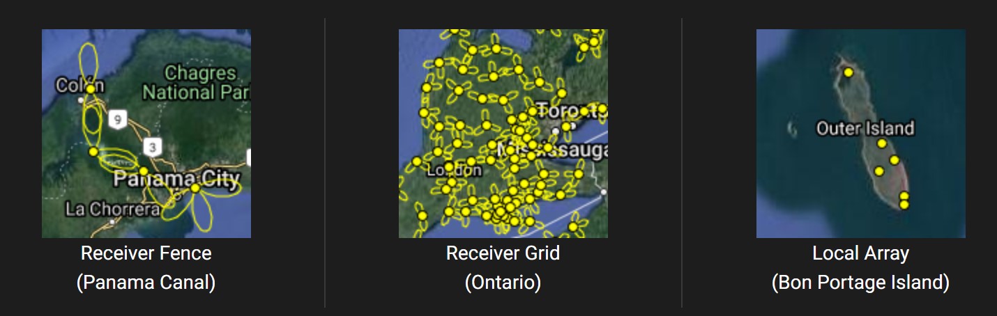
Motus station coverage and effectiveness for detecting movement of tagged birds in a region can be impacted by station placement and array design and is important to consider for selecting tag deployment locations. Motus station placement can vary from local arrays to regional grids or “fences” crossing known areas of high movement (Figure 1). Areas with grids or “fences” are more likely to detect regional movements (Birds Canada, 2023a). A priori knowledge of species movements and known migration strategies (e.g., coastal, interior, or offshore) can help to recognize areas where birds are likely to occur and subsequently, if station coverage is present. The working group recommends targeting animal tagging efforts within the range (i.e., a few km) of at least one confirmed active Motus receiver.
Bird-specific considerations
Given that offshore movements are significantly more common in fall than in spring (Curley et al., 2025; Williams et al., 2024), comprising both a higher total amount of offshore migratory activity as well as a higher proportion of offshore activity relative to onshore activity, it is generally recommended for many species to deploy tags in summer or fall at a tagging location north of the offshore region of interest, to focus on offshore data collection during the autumn migration season, as well as to leverage current Motus coverage in the Northeast. For capture of nocturnal bird species during migration, collaborating with established migration monitoring efforts can help identify areas and time periods of high species occurrence for capture and tagging. For species such as shorebirds, staging locations can offer high concentrations of birds for capture. Tracking fall migration is recommended as a priority for understanding offshore movements in relation to offshore energy development in the U.S. Atlantic. Data on spring migration also represents a data gap for many species, including some marine birds and shorebirds, and requires further study; however, tracking technologies other than Motus (i.e. satellite telemetry) may be more appropriate methods of study for these species in the nonbreeding spring migratory seasons.
For marine birds and some shorebirds, tag deployment should be focused at nesting sites when possible. Tag deployments at nesting colonies can be a reliable place to catch birds during the limited window of incubation, but capture becomes more difficult once chicks have hatched. Identifying a target window at breeding sites requires existing or additional breeding site monitoring. If nesting site tagging is not feasible (for example, if a transmitter deployed at the breeding site would not last long enough to provide detection data in the geographic region of interest), then researchers may need to explore options for tag deployment during known congregation areas on migration (i.e. staging areas) or consider alternative tagging technologies where appropriate for the focal species.
Bat-specific considerations
Timing of tracking studies will depend on the life history of targeted bat species and the density of Motus towers in the region. For migratory bats, given the coverage of the Motus network in the northeast US and maritime Canada, tags should be deployed in these areas in late summer or early fall. Spring movement of migratory bats is not well documented and will be much harder to quantify without a stronger Motus network in southern states, long-term attachment techniques (see Bat Attachment Methods), and a better grasp on reliable capture sites in the southern range of some species. While the committee does not recommend against tracking spring migration, researchers should treat such efforts as pilot projects that will inform future work. Motus can be useful in the southern range of migratory bats if tagging study designs include more active detection efforts and are paired with landscape-scale acoustic monitoring (for guidance, see NABat; https://www.nabatmonitoring.org/ ) or assistance by aircraft. Given the advancement of new attachment techniques, studies targeting long duration attachments (>30 days) should consider releasing tags wherever animals are easily captured. In this case, more animals with tags will likely provide a window into large scale movements as they move through the network, regardless of their release location.
There are limited cases where Motus will provide useful data for tracking hibernating bats, due to their narrow home ranges during summer maternity season and Motus tower coverage. While not a high priority for the Working Group, additional data on migratory movements in the fall, before hibernation, or in the spring, immediately following emergence from hibernation, will help associate summer and winter habitat and document any activity offshore associated with migration. Studies using Motus will likely need to be specifically designed (e.g., strategic placement of towers) for maximum impact.
Bat Attachment Methods
What are the recommended tag attachment methods for bats?
Non-toxic glues are currently the most accepted method attachment method for bats, using various veterinary-grade glues, including surgical cement (e.g., Torbot Bonding Cement) or cyanoacrylate (e.g., GLUture or Vetbond). Tags are attached to the interscapular region on a bat’s back after trimming some fur to maximize skin contact with glue. Glue is most effective for short-term tracking studies (i.e., days or weeks). The tag specifications and attachment method should be configured for each study with consideration of the research questions and desired tracking duration. Further information can be found in resources such as Behavioral and Ecological Methods for the Study of Bats (Kunz and Parsons, eds, 2009) and Loeb et al. (2025).
The Working Group recognizes a need for exploration and validation of new attachment techniques. We recommend further testing (with evaluation of possible tag effects) of collaring and suturing techniques (Castle et al., 2015; Weller et al., 2016) as add-on objectives to evaluate those methods for widespread adoption.
Motus Station Coverage
Where would additional Motus station coverage be useful for understanding offshore movements in the U.S. Atlantic?
Understanding Current Motus Coverage
Most stations in North America operate on at least one of the two main Motus radio frequencies (166.380 MHz and 434 MHz; see Motus Tag Frequencies). Dual-mode stations (operating on both frequencies) are becoming more common in some areas. Another frequency, 2.4 GHz, was recently introduced by the company Cellular Tracking Technologies (CTT), which can be paired in a dual-mode or tri-mode set-up.
Motus.org provides interactive tools to help researchers identify coverage gaps and understand frequency-specific coverage. The interactive map shows the location of stations, color coded by frequency (e.g., 166.380 MHz, 434 MHz, 2.4 GHz, dual mode, or tri-mode). Most dual mode stations are equipped to detect 166.380 and 434 MHz signals. Detailed information on station capabilities is available through the interactive map dashboard. In the “map legend” section of the interactive map, other station-specific information such as antenna types and orientations and the approximate date of last data upload can also be seen for all stations on the network.
Individual station details, such as the most recent data upload date (Figure 2), should be reviewed carefully. If Motus Central stops receiving station data, the station will be marked as “inactive” but not removed from the dashboard. Inactive status indicates that the station may not be collecting data or sending data and thus should not be considered a reliable receiving station. Determining a station’s operating status is complicated by the fact that not all stations automatically upload data to Motus. Stations that require manual downloads and uploads of data to Motus Central, which is common among offshore stations, may have extended periods between data uploads. Researchers are encouraged to reach out to specific station operators or through the Motus Community to answer specific questions about individual station status.
As of early 2026, major onshore coverage gaps in the Western Hemisphere include interior Canada, parts of the Southeast U.S., coastal areas along the Gulf of Mexico, and much of Mexico, Central and South America, and the Caribbean.
Critical Gaps for Understanding Offshore Movement
To improve our understanding of offshore movements of aerofauna in the U.S. Atlantic, expansion of dual-mode Motus station coverage (434 MHz and 166.380 MHz) should be prioritized as follows:
Offshore sites: Any opportunity to deploy stations offshore, including on islands and offshore infrastructure, should be prioritized. Information on deploying Motus stations on offshore structures is available in the Guidance Document for Deploying Motus Stations on Offshore Wind Turbines and Buoys (Loring, Carlson, Gobeille, Deluca, et al., 2023).
Coastal areas: Stations in coastal areas collect important movement data for birds and bats moving coastally and potentially departing for larger offshore movements. Gaps along the coast should be prioritized for placement of new stations (Figure 1), especially areas of known migratory departure or stopover sites where migratory birds and bats may congregate before or after over-water crossing like the Delmarva Peninsula, which is known for concentrating birds during migration.
Tag deployment sites: Ensuring station coverage at tag deployment sites can help confirm departure information of tagged individuals and often indicate direction of flight, which can be particularly useful for indicating offshore movements at coastal tagging sites.
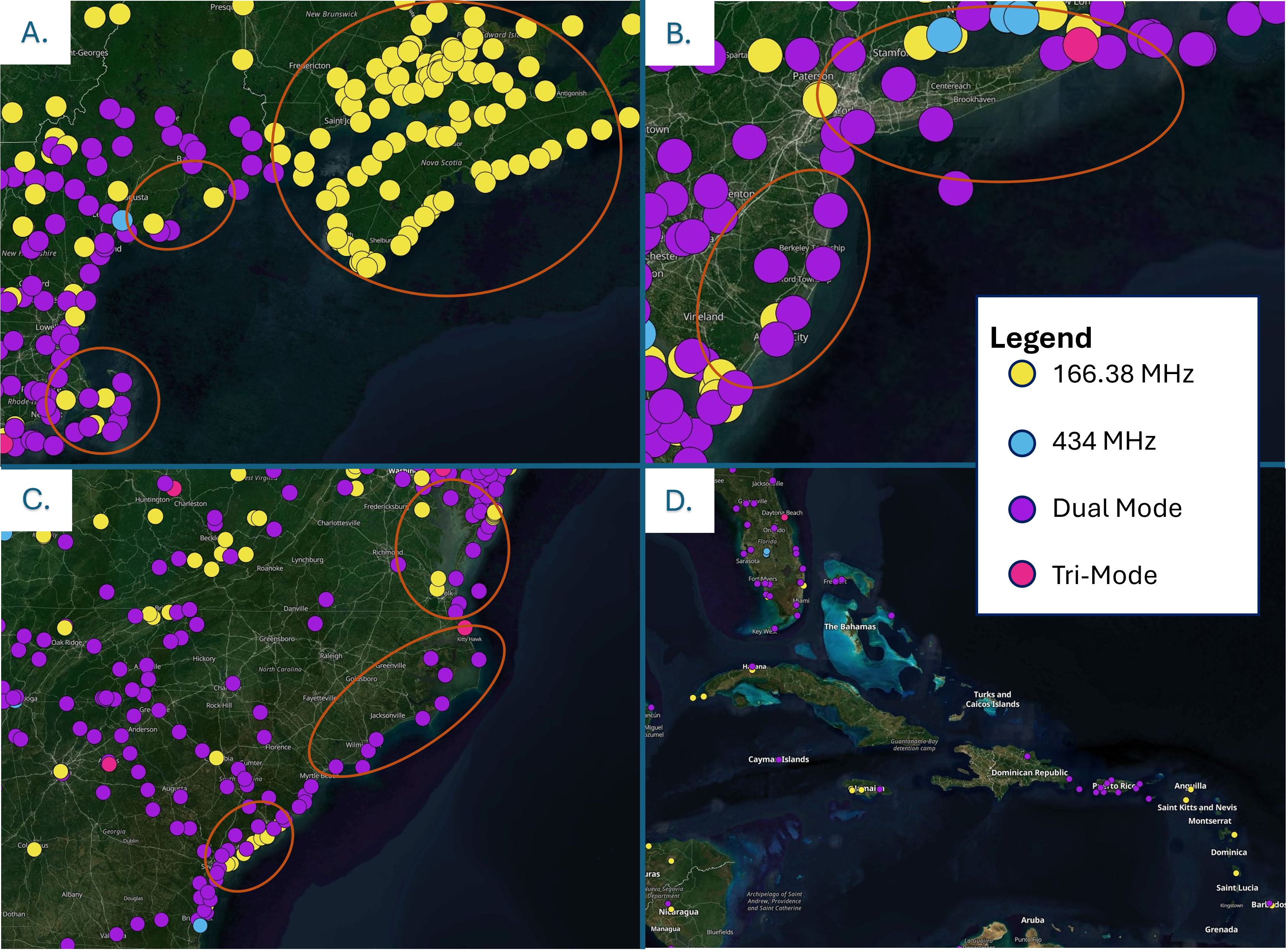
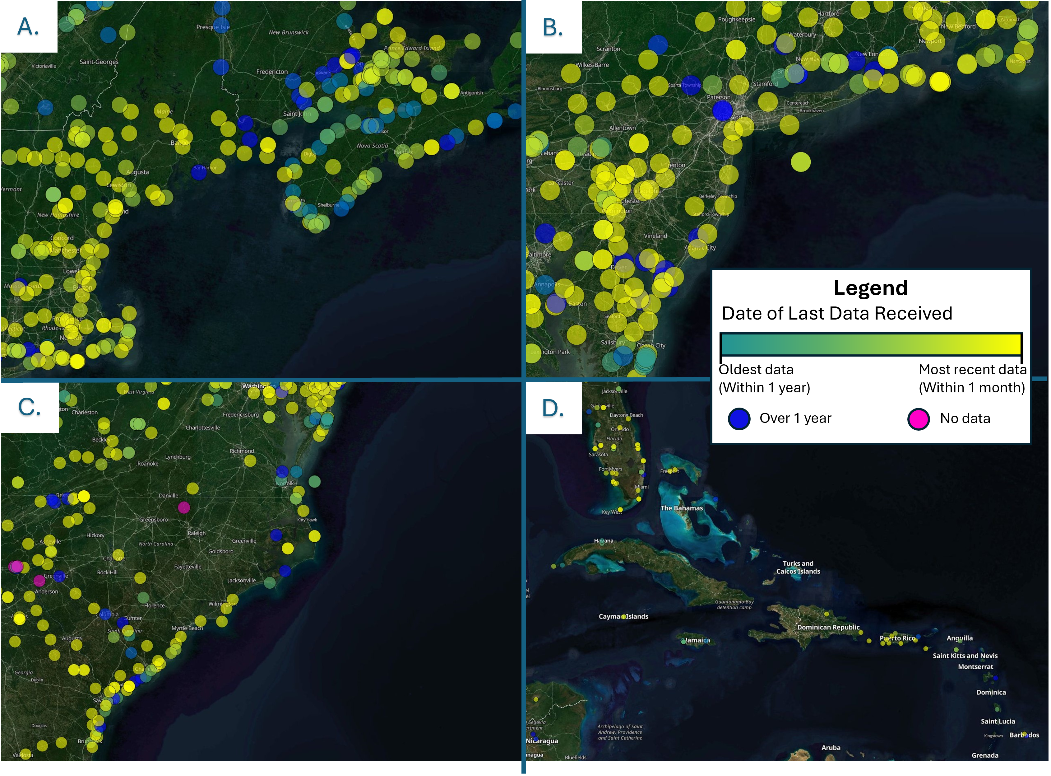
It’s important to note that 2.4 GHz is an emerging radio frequency used for tracking wildlife and further testing will be needed to determine its utility for offshore use. 2.4 GHz tags (also known as Blū series or Blū tags) can be detected at stations equipped with 2.4 GHz antennas and receiving equipment and through an extended network of Bluetooth enabled devices. While Blū tags can be detected using the Bluetooth network, expanding coverage of 2.4 GHz through upgrading existing stations or deploying new tri-mode stations, as practical, will expand its general utility, which could be especially helpful for tracking very small birds and bats (see Motus Tag Frequencies).
Maintaining and expanding a strong Motus array
Stations in coastal and offshore areas are often exposed to harsh conditions, so proper installation and maintenance is essential for keeping them online and maintaining consistent coverage across the Motus network (Birds Canada, 2023b; Loring, Carlson, Gobeille, Deluca, et al., 2023). For stations with manual data downloads, data retrieval/maintenance visits should be conducted at least every 6 months (Loring, Carlson, Gobeille, Deluca, et al., 2023). Remote data connectivity is therefore preferred where feasible to allow for automatic upload, remote monitoring of station health, and timely identification of and response to maintenance issues. Additional information on installation and maintenance is available from a range of sources, including several sources listed in the “Guidance Resources” section on the RWSC Bird and Bat Tracking Working Group Webpage.
Acronyms
USFWS – United States Fish and Wildlife Service
ESA – Endangered Species Act
RWSC – Regional Wildlife Science Collaborative
CTT – Cellular Tracking Technologies
USGS – United States Geological Survey
BBL – Bird Banding Laboratory
IACUC – Institutional Animal Care and Use Committee
SWAP – State Wildlife Action Plan
SGCN – Species of Greatest Conservation Need
Glossary of Terms
Array – A subset of automated radio telemetry stations or towers within the Motus Wildlife Tracking System, which are used to track movement behavior of tagged flying animals (birds, bats, insects).
Bird and Bat Subcommittee – The Bird and Bat Subcommittee of the Regional Wildlife Science Collaborative (RWSC) is a group of experts with a range of expertise across Atlantic ecosystems. Subcommittee members share information about ongoing and planned research, identify key data gaps, and help maintain alignment and coordination among research and data collection teams.
Bird and Bat Tracking Working Group –The Bird and Bat Tracking Working Group of the Regional Wildlife Science Collaborative (RWSC) was established by the Bird and Bat Subcommittee to prioritize regional coordination among federal agencies, states, industry, academic, and nonprofit organizations for bat and bird tagging and tracking efforts.
Burst interval/burst rate – Motus-compatible tags emit “pulses,” brief radio transmissions measured in milliseconds. Motus tags typically emit four pulses sequentially, with the “pulse interval” between pulses also measured in milliseconds. Each group of pulses is a “burst”. The timing between successive bursts is the “burst interval,” or burst rate, which can be configured during tag manufacture and is measured in seconds. For Lotek-manufactured tags (166 MHz), the burst interval and Lotek Tag ID combined are used to encode the Motus Tag ID, meaning that multiple sequential bursts must be detected at the same station for the successful detection and identification of a specific tag. There is often a tradeoff between shorter burst interval (which increases the chance of a fast-moving animal being detected by a station) and battery life of the tag.
Carry Weight – Rule of thumb to determine the appropriate weight of tags and other attachment materials for markers on birds and bats to avoid tag effects (see “tag effects”). For birds, the tag, tag attachment materials, band, and any other auxiliary markers should generally not exceed more than 2% of the measured mass of an individual bird for leg tag attachments 3% for all other attachment methods, though the Bird Banding Lab may grant exceptions under specific circumstances. For bats, the tag, band, and any other auxiliary markers and attachment materials, such as glue, should not exceed more than 5% of the measured weight of an individual bat.
Coastal – Shorelands adjacent to marine coastal zones including islands, transitional and inter-tidal areas, salt marshes, wetlands, and beaches. For purposes of Motus station deployments, “coastal” sites may include station deployments farther inland from the coastal zone, but should be within 1 km and in clear line of site of open water.
Calibration – In general terms, calibration quantifies the relationship between the readings of an instrument and the relevant units of the system being calibrated. Calibration is an important step in preparing an instrument for use because it controls for uncertainty in the assumptions made regarding the manufacturer’s claims to accuracy of its measurements of the signal being received. In the context of Motus, stations require calibration to measure and map a station’s real three-dimensional detection range of tags under real-world field conditions. This process allows researchers to understand how far tags can be detected and any potential blind spots associated with a station.
Conditions and stimuli – Conditions and stimuli are attributes of a wind facility like lighting, distance from shore, turbine spacing, etc. that may influence how individual animals respond to the presence of offshore wind development. Conditions and stimuli are one of the main factors that determine a bird’s or bat’s potential risk from offshore wind development (along with exposure and vulnerability; see “risk”).
Day roost – Day roosts are secluded, dark, and sheltered locations where bats rest during the day, such as caves, rock crevices, tree bark, or anthropogenic structures. These spots protect them from predators and weather, allowing them to conserve energy before emerging at dusk to forage. Common day roosts include trees and man-made structures.
Deployment – Deployment of a Motus station refers to a single station configuration including the location of the station, the exact equipment models and number, and the configuration of equipment including antenna bearings and height. Motus tag deployment refers to the time period when a tag was active in the field or on an animal starting when once the tagged animal is released. Within the Motus Wildlife Tracking System, the term “deployment” specifically refers to the availability of metadata for a single instance of a tag or station being set up or activated.
Dual-mode – Dual-mode refers to Motus stations equipped to detect tags at two different frequencies. Most often, dual-mode stations are equipped to detect Lotek tags (166.38 MHz) and CTT tags (434 MHz), which increases the versatility of the network. While less common, some dual-mode stations are configured to detect 2.4 GHz (a newer frequency offered by CTT) in the place of 166.380 MHz or 434 MHz. Dual mode stations are becoming increasingly widespread across the Motus system, especially in the northeastern United States.
Exposure – Describes how the spatiotemporal patterns of space used by animals overlap with a potential threat (e.g. offshore wind development).
Fasting body mass – Total body mass measured from a fasting animal. Typically considered the body mass measured at the start of foraging following daily periods of inactivity (e.g., mass at sunset for bats or sunrise for birds).
Fat-free mass – Total body mass minus fat mass, which in birds, is important for understanding fuel consumption during migration and determining safe carry weights for auxiliary markers like tags.
(Radio) Frequency – Radio frequency refers to the oscillation rate of electromagnetic radiation (radio waves). Radio frequencies typically range from 3kHz to 300 GHz, falling on the lower end of the electromagnetic spectrum, and are characterized by low-energy, non-ionizing radiation. Motus stations receive frequencies emitted from tags at 166.380 MHz, 434 MHz, and 2.4 GHz in the Western Hemisphere.
Hibernating bats – A collective term for a behavioral grouping of bats that hibernate. North American hibernating bat species include little brown bat (Myotis lucifugus), big brown bat (Myotis fuscus), northern long-eared bat (Myotis septentrionalis), tricolored bat (Perimyotis subflavus), and Indiana bat (Myotis sodalis). Non-hibernating bats in northern latitudes are typically migratory (i.e., they move south for the winter instead of seasonally hibernating; see “migratory tree bat”).
Marine Birds – Any bird that interacts with the offshore marine environment at or below the water’s surface for foraging, roosting, loafing, and/or other behaviors. This includes all seabirds, as well as waterbirds and waterfowl that utilize the ocean during parts of their life cycle, and other species, such as phalaropes, that forage or roost on the water’s surface. Species whose only interaction with the offshore marine environment is to fly over it during migration (e.g., most songbirds and shorebirds) are not included in this definition.
Maternity roost – Pregnant female bats form large groups referred to as maternity colonies, which are often far removed from hibernacula areas. Maternity colonies usually contain up to 100 adult female bats to maintain optimal body temperature for their pups. The maternity colony selects one or more maternity roosts, which can be trees, caves, or man-made structures, where they care for their young during maternity season (April to August in the Northern Hemisphere).
Migratory tree bats – Some species of bats migrate substantial distances between summer maternity roots and locations with milder climates, where they spend nonbreeding (e.g., wintering) periods. Species of migratory tree bats in temperate North America include hoary bat (Lasiurus cinereus), eastern red bat (L. borealis), and silver-haired bat (Lasionycteris noctivagans). Migratory tree bats are solitary and roost during the day in trees, foliage, or under bark. Non-migratory bats in northern latitudes are known as “hibernating bats”.
Motus – The Motus Wildlife Tracking System (“Motus” or “Motus network”), developed and managed by Birds Canada, is an international collaborative research network that uses automated radio telemetry to track the movement of birds, bats, and insects.The network is comprised of more than 2,000 Motus stations, each equipped with an antenna tuned to receive one or more radio frequencies that correspond to transmitters fitted to animals.
Motus Central – Motus Central is composed of staff from Birds Canada, specialist contractors, and leadership staff from partners, and is responsible for data management, system operation and development, and general coordination and support of the Motus network.
NABat – NABat, short for North American Bat Monitoring Program, is a multi-national, multi-agency coordinated continental bat monitoring program. The program is made up of an extensive community of partners across the continent who utilize standardized protocols to gather information on bat populations and trends, inform responses to stressors, and sustain viable bat populations.
Offshore – The Bureau of Ocean Energy Management (BOEM) defines “offshore” as the submerged lands, subsoil, and seabed of the Outer Continental Shelf (OCS), typically extending from 3 nautical miles seaward of state coastal waters up to 200 nautical miles, or more, to the edge of the US Exclusive Economic Zone (EEZ).
Power-regulated tags – Power-regulated tags, used in wildlife tracking studies, contain an internal power source such as a battery. These tags are more suitable than solar tags for tracking nocturnal migrants offshore because they are not fully dependent on sun exposure, allowing 24-hour detections and a constant signal strength. Solar-powered Motus tags cannot operate when they are not actively receiving light, and their power may also fluctuate, making their detectability by Motus stations temporally variable.
Receiver – A Motus automated telemetry receiver is the computer that records detections of automated radio telemetry tags and is a key component of Motus stations. There are three main Motus receiver models, including Lotek Wireless’ receivers (SRX600, 800 and D-series receivers), CTT Sensorstations and Nodes, and the open-source SensorGnome. Manual hand-held receivers are also available.
Risk –In the context of offshore wind development, risk to birds and bats is determined by a combination of three factors: exposure, conditions and stimuli, and vulnerability.Risk is evaluated for all phases of an offshore wind project (including construction, operations and maintenance, and decommissioning) and represents the overall likelihood that a project could adversely affect a bird or bat species.
Sensitivity – Refers to how easily birds or bats are likely to respond or react to conditions and stimuli. Sensitivity can be considered at either the individual or population level and can be quantified in terms of an animal’s morphology, behavior, habitat flexibility, conservation status, or other factors.
(Motus) Station – Sometimes referred to as a tower, a Motus station is an automated radio telemetry station designed to listen to specific types of radio transmitters used to track wildlife. These stations comprise the physical ground-based infrastructure compatible with the Motus Wildlife Tracking System. A station consists of a radio receiver (computer) as well as peripherals such as radio antennas, cables, a mounting structure, and a power supply.
Tag effect –Tag effect refers to how a bird’s or bat’s behavior may be altered following tag deployment, or to the resulting fitness consequences of such behavioral change. Handling of the animal to secure the tag, the harness/attachment method for the tag, and the weight/positioning of the tag itself may cause adverse effects to individuals carrying the tags (such as changes in survival probability) or adverse changes in their reproductive success. Strategies such as limiting tag weight in relation to body mass (see “Carry Weight”) are used by researchers to help avoid these effects.
(Bird and Bat) Tracking Database – A database of planned or active projects relevant to understanding offshore movement of birds and bats in the U.S. Atlantic that is managed by the Regional Wildlife Science Collaborative (RWSC) Bird and Bat Tracking Working Group.
Tri-Mode – Tri-mode refers to the ability for Motus stations to detect tags at three different frequencies (434 MHz, 166.38 MHz, and 2.4 GHz in the Western Hemisphere).
(Motus) Tag –A Motus tag is a miniaturized radio transmitter that can weigh as little as 0.06 grams, such that they can be affixed to birds, bats, and even insects. Tags are coded with unique IDs allowing animals to be tracked individually using an automated receiver. Motus tags operate on specific frequencies (166.380 MHz, 434 MHz, and 2.4 GHz in the Western Hemisphere) compatible with the Motus Wildlife Tracking System, allowing them to be detected on Motus stations operating on the same frequencies and contributing to a shared Motus database. Motus tags are currently manufactured by two companies in North America: Lotek (166.380 MHz) and Cellular Tracking Technologies (CTT; 434 MHz and 2.4 GHz).
Vulnerability –Vulnerability is used to describe how an animal that is exposed to a potential threat, such as offshore wind development, is affected in terms of individual and population-level sensitivity. Individual sensitivity is driven by factors such as behavior, morphology, response to disturbance, and habitat flexibility, among other factors. Population sensitivity is defined by population characteristics, such as conservation status and demographic parameters. The vulnerability of animals to offshore wind development is partially dictated by site-level characteristics that may influence responses. For more information, see “risk.”
Literature Cited
Avian Displacement Guidance Committee. (2024). Guidance for Pre- and Post-Construction Monitoring to Detect Changes in Marine Bird Distributions and Habitat Use Related to Offshore Wind Development. Report to the Offshore Wind Environmental Technical Working Group. (p. 100). www.nyetwg.com/avian-displacement-guidance.
Birds Canada. (2023a). Motus. Station Placement. https://docs.motus.org/en/stations/station-placement
Birds Canada. (2023b). Motus Docs. https://docs.motus.org/en
Birds Canada. (2023c). Motus Wildlife Tracking System Collaboration Policy. https://motus.org/resources/policy/
Birds Canada. (2026). motus: Fetch and use data from the Motus Wildlife Tracking System. https://motusWTS.github.io/motus/
BOEM. (2023). Conditions of Construction and Operations Plan Approval Lease Number OCS-A 0486 [Revolution Wind] (p. 108 pp.). U.S. Department of the Interior, Bureau of Ocean Energy Management. https://www.boem.gov/sites/default/files/documents/renewable-energy/state-activities/Cond%20of%20COP%20Appr_REV%20OCS-A%200486_0.pdf
BOEM. (2024a). Conditions of Construction and Operations Plan Approval Lease Number OCS-A 0483 [Coastal Virginia Offshore Wind] (p. 99 pp.). U.S. Department of the Interior, Bureau of Ocean Energy Management. https://www.boem.gov/sites/default/files/documents/renewable-energy/state-activities/CVOW-C-Conditions-COP-Approval-OCS-A-0483.pdf
BOEM. (2024b). Conditions of Construction and Operations Plan Approval Lease Number OCS-A 0512 [Empire Wind]. 104.
BOEM. (2024c). New York Bight Final Programmatic Environmental Impact Statement. Volume II Appendix G: Mitigation and Monitoring. Bureau of Ocean Energy Management OCS EIS BOEM 2024-054.
Crichton, D. (1999). The risk triangle (Ingleton, J.). Tudor Rose. https://www.ilankelman.org/crichton/1999risktriangle.pdf
Curley, S. R., Farnsworth, A., White, T. P., Shamoun-Baranes, J., & Dokter, A. M. (2025). Differences between terrestrial and offshore bird migration: Implications for offshore wind energy. Journal of Applied Ecology, 62(10), 2800–2813. https://doi.org/10.1111/1365-2664.70158
Friedenberg, N. A., & Frick, W. F. (2021). Assessing fatality minimization for hoary bats amid continued wind energy development. Biological Conservation, 262(August), 109309. https://doi.org/10.1016/j.biocon.2021.109309
Goodale, M. W., & Milman, A. (2016). Cumulative adverse effects of offshore wind energy development on wildlife. Journal of Environmental Planning and Management, 59(1), 1–21. https://doi.org/10.1080/09640568.2014.973483
Jonasson, K. A., Corcoran, A. J., Dempsey, L., Weller, T. J., & Clerc, J. (2025). Bats flying through a Y-maze are visually attracted to wind turbine surfaces. Biology Letters, 21(8), 20250242. https://doi.org/10.1098/rsbl.2025.0242
Kelsey, E. (2025). Revised Marine Bird Collision and Displacement Vulnerability Index for U.S. Pacific Outer Continental Shelf Offshore Wind Energy Development (Data Report) [Data Report].
Lloyd, J. D., Butryn, R., Pearman-Gillman, S., & Allison, T. D. (2023). Seasonal patterns of bird and bat collision fatalities at wind turbines. PLOS ONE, 18(5), e0284778. https://doi.org/10.1371/journal.pone.0284778
Loring, P., Carlson, E., Gobeille, D., Deluca, R., Makenzie, S., Berrigan, L., Williams, K., Gilbert, A., & Adams, E. (2023). Guidance Document for Deploying Motus Stations on Offshore Wind Turbines and Buoys. Report to the New York State Energy Research and Development Authority (NYSERDA), Albany, New York, version March 15, 2023.
Loring, P., Carlson, E., Gobeille, D., Makenzie, S., Berrigan, L., Williams, K., Gilbert, A., & Adams, E. (2023). Monitoring Framework for Automated Radio Telemetry at Offshore Wind Projects in the U.S. Atlantic. version March 15, 2023. Report to the New York State Energy Research and Development Authority (NYSERDA), Albany, New York. https://motus.org/wp-content/uploads/2023/03/Monitoring-Framework-for-Automated-Radio-Telemetry-at-Offshore-Wind-Projects-v-20230315.pdf
Motus Wildlife Tracking System. 2023. Birds Canada, Port Rowan, Ontario. Available: https://motus.org. Accessed: 02/06/2026.
North American Bird Conservation Initiative. (2025). The State of the Birds, United States of America, 2025. https://StateoftheBirds.org
Northeast Fish and Wildlife Diversity Technical Committee. (2024). Northeast Regional Species of Greatest Conservation Need (RSGCN) Database, version 4.1. Prepared for the Northeast Association of Fish and Wildlife Agencies by Terwilliger Consulting, Inc.
O’Mara, M. T., Wikelski, M., & Dechmann, D. K. N. (2014). 50 years of bat tracking: Device attachment and future directions. Methods in Ecology and Evolution, 5(4), 311–319. https://doi.org/10.1111/2041-210X.12172
Paton, P. W. C., Loring, P. H., Cormons, G. D., Meyer, K. D., Williams, S., & Welch, L. J. (2020). Fate of Common (Sterna hirundo) and Roseate Terns (S. dougallii) with Satellite Transmitters Attached with Backpack Harnesses. Waterbirds, 43(3–4). https://doi.org/10.1675/063.043.0315
Peterson, T. S., Pelletier, S. K., Boyden, S. A., & Watrous, K. S. (2014). Offshore acoustic monitoring of bats in the Gulf of Maine. Northeastern Naturalist, 21, 154–163.
Regional Synthesis Workgroup of the Environmental Technical Working Group. (2023). Responsible Practices for Regional Wildlife Monitoring and Research in Relation to Offshore Wind Energy Development (p. 44 pp.). New York Offshore Wind Environmental Technical Working Group. www.nyetwg.com/regionalsynthesis-workgroup
Regional Wildlife Science Collaborative. (2024). Integrated Science Plan for Offshore Wind, Wildlife, and Habitat in the U.S. Atlantic Waters. Version I.0. Regional Wildlife Science Collaborative for Offshore Wind. https://rwsc.org/science-plan.
Robinson Willmott, J. C., Forcey, G., & Kent, A. (2013). The relative vulnerability of migratory bird species to offshore wind energy projects on the Atlantic Outer Continental Shelf: An assessment method and database. Final Report to the US Department of the Interior, Bureau of Ocean Energy Management, Office of Renewable Energy Programs. OCS Study BOEM, 207, 275.
Solick, D. I., & Newman, C. M. (2021). Oceanic records of North American bats and implications for offshore wind energy development in the United States. Ecology and Evolution, 11(21), 14433–14447. https://doi.org/10.1002/ece3.8175
Southeast Wildlife Diversity Committee. (2019). Regional Species of Greatest Conservation Need in the Southeastern United States. Prepared for Wildlife Diversity Committee Southeast Association of Fish and Wildlife Agencies by Terwilliger Consulting, Inc. https://secassoutheast.org/pdf/SEAFWA_RSGCN_Final_Report_20190715.pdf
Taylor, P. D., Crewe, T. L., Mackenzie, S. A., Lepage, D., Aubry, Y., Crysler, Z., Finney, G., & Charles, M. (2017). The Motus Wildlife Tracking System: A collaborative research network. Avian Conservation And, 12(1).
U.S. Fish and Wildlife Service. (2021). Birds of Conservation Concern 2021 (p. 48). United States Department of the Interior, U.S. Fish and Wildlife Service, Migratory Birds, Falls Church, Virginia. https://www.fws.gov/sites/default/files/documents/birds-of-conservation-concern-2021.pdf
U.S. Fish and Wildlife Service. (2024). National Domestic Listing Workplan for Fiscal Years 2024-2028. https://www.fws.gov/sites/default/files/documents/2024-05/national-domestic-listing-workplan-2024.pdf
USGS. (2018, May 30). Auxiliary Marking Authorizations. Bird Banding Laboratory. https://www.usgs.gov/labs/bird-banding-laboratory/science/auxiliary-marking-authorizations
Weller, T. J., Castle, K. T., Liechti, F., Hein, C. D., Schirmacher, M. R., & Cryan, P. M. (2016). First Direct Evidence of Long-distance Seasonal Movements and Hibernation in a Migratory Bat. Scientific Reports, 6(1), 34585. https://doi.org/10.1038/srep34585
Williams, K. A., Gulka, J., Cook, A. S. C. P., Diehl, R. H., Farnsworth, A., Goyert, H., Hein, C., Loring, P., Mizrahi, D., Petersen, I. K., Peterson, T., Press, K. M., & Stenhouse, I. J. (2024). A framework for studying the effects of offshore wind energy development on birds and bats in the Eastern United States. Frontiers in Marine Science, 11, 1274052. https://doi.org/10.3389/fmars.2024.1274052
Footnotes
Empire Offshore Wind Final Environmental Impact Statement: https://www.boem.gov/sites/default/files/documents/renewable-energy/state-activities/Empire_Wind_FEIS_App_H_Mitigation%26amp%3BMonitoring_0.pdf↩︎
RWSC research database: https://database.rwsc.org↩︎
Sunrise Wind Farm Project Post-construction Avian Bird and Bat Monitoring Framework: https://www.boem.gov/sites/default/files/documents/renewable-energy/state-activities/SRW01_COP_AppP2_AvianBatPCM%20Framework_2022-08-19_508.pdf↩︎
Sunrise Wind Farm BOEM Conditions of Construction and Operations Plan Approval: https://www.boem.gov/sites/default/files/documents/renewable-energy/state-activities/5774_App%20A_Sunrise%20Wind_Conditions%20of%20COP%20Approval_OCS-A%200487_FINAL.pdf↩︎
Revolution Wind Avian and Bat Post-construction Monitoring Framework: https://www.boem.gov/sites/default/files/documents/renewable-energy/state-activities/RevWind-USFWS_BA_Appendix-C.pdf↩︎
Vineyard Wind 1 Offshore Wind Energy Project Final Environmental Impact Statement: https://www.boem.gov/sites/default/files/documents/renewable-energy/state-activities/Vineyard-Wind-1-FEIS-Volume-1.pdf↩︎
Southcoast Wind Draft Post-construction Avian and Bat Monitoring Framework: https://www.boem.gov/sites/default/files/documents/SouthCoast_FEIS_AppG_Mitigation_Monitoring_Clean_508.pdf↩︎
Mayflower Wind Project Biological Assessment: https://www.boem.gov/sites/default/files/documents/renewable-energy/state-activities/Mayflower%20Wind_USFWS_BA.pdf↩︎
South Fork Wind Farm Project BOEM Conditions of Construction and Operations Plan Approval: https://www.boem.gov/sites/default/files/documents/renewable-energy/state-activities/SFWF-COP-Terms-and-Conditions.pdf↩︎
South Fork Wind Farm Final Environmental Impact Statement: https://www.boem.gov/sites/default/files/documents/renewable-energy/state-activities/SFWF%20FEIS.pdf↩︎
Current Motus coverage can be viewed using the interactive Explore tool on Motus.org.↩︎
Available resources for species mass include American Society of Mammologists, Mammalian Species accounts (https://www.mammalsociety.org/publications/mammalian-species) and the Cornell Lab, Birds of the World accounts (https://birdsoftheworld.org/bow/home).↩︎